The late, incomparable Charles Kuralt of CBS News “On the Road” fame once counted a lonely route in Nebraska among America’s 10 most beautiful highways.
The statement turned some heads and sparked debate. Remember, Kuralt traveled widely in all 50 states, and he had an eye for the extraordinary at every turn in the road.
But many folks find it counter-intuitive to join the concept of scenic with the name Nebraska.
Not much doubt about it: As a state, Nebraska has a serious identity problem when it comes to the nation’s vacationers, photographers, and travel writers.
A recent national survey asked prospective vacationing families to list states they would be most likely to visit. Nebraska finished dead last for the fourth consecutive year.
An advertising agency tasked with serving up a new tourism slogan for the state arrived at this: “Nebraska — Honestly, It’s Not for Everyone.”
Ouch.
As a longtime visitor with family roots in the Cornhusker State, I’m left to ponder this negativity. After all, I believe Nebraska — and every other U.S. state — offers unique attractions and scenic beauty worth seeing in person.
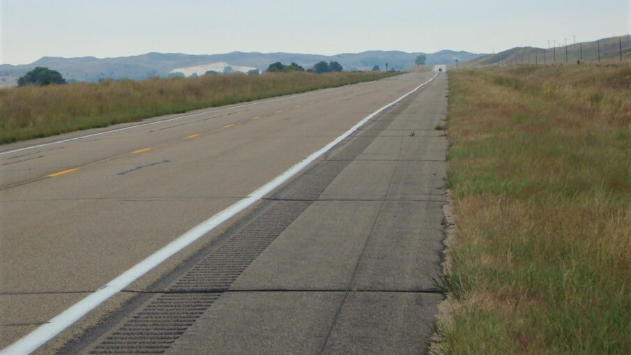
I think a key culprit that influences the state’s lackluster reputation among travelers is paved with asphalt: Interstate Highway 80.
This ribbon of pavement is the shortest Interstate highway route between the coasts, connecting New York and San Francisco. It is built to get goods and travelers where they need to go in the shortest time. The midway point between coasts is in — you guessed it — Nebraska, America’s only triple-landlocked state.
I-80 connects the state’s two major cities of Omaha and Lincoln, then continues west along the Platte River valley. This is some of the flattest, most monotonous driving you will find anywhere — more than 400 miles of flat farm fields and sparsely populated ranch land.
Unfortunately, this is what most of the state’s visitors see as they’re heading somewhere else. They leave with a sense of relief that the Nebraska portion of their trip is done.
Kuralt probably was not a fan of I-80. But he did love Nebraska Highway 2, a state road that connects Nebraska City on the Missouri River in the southeast with the northwest Nebraska panhandle, a driving distance of more than 500 miles.
Highway 2 reveals the largest stretch of sand dunes in North America. It shows you a migration station for half a million cranes each March that attracts observers from around the world. It takes you to a slice of roadside Americana called Carhenge. And it enters South Dakota in an area where buffalo herds roam under sheer cliffs hundreds of feet high.
It’s not a place to encounter industry, urban sprawl or even corn fields. From east to west, starting near Grand Island, Nebraska, let’s examine what your investment in this surprising travel find will yield.
Crane Trust Nature Center is open all year
A good place to leave I-80 and begin your Highway 2 adventure is Exit 305 about 150 miles west of Omaha and just east of the town of Wood River. On Alda Road, just south of the Interstate, you’ll find the Crane Trust Nature Center.
Late each winter, a migratory event considered among the most important in North America unfolds in these skies west of Grand Island. About 80 percent of the world’s Sandhill Cranes converge on land in the “Big Bend” area of the Platte River. Other species of birds will join them. Scientists recently documented the long-held suspicion that this sand bar in the river is the world’s largest crane roost. Photographers and birding enthusiasts arrive here each March from all over the world to witness the spectacle in the sky.
VisitGrandIsland.com quotes renowned English anthropologist Jane Goodall: “Nebraska is special to me. I’ve traveled far and wide, and coming to Nebraska, and seeing and hearing the cranes always restores my soul.”
If you can’t make it here in March, you can still learn more about the migration at the center, which is open all year and documents the annual event. You can even book a blind from which to watch the migration, but that requires some early planning.
From here, you can travel about 18 miles north via Alda Road, U.S. Highway 30, and state highways 18 and 37 to reach Highway 2. Then head west.
Visit the Largest Tract of Sand Dunes in North America
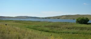
When you begin travel west on Highway 2, you will be driving the Nebraska Sandhills Journey Scenic Byway. The region was designated a National Natural Landmark in 1984.
These are sand dunes, but they’re covered with grasses and other vegetation. It’s one of the largest sand dune sectors in the world, and the largest in North America. Because early settlers to Nebraska were prospective farmers, this region quickly became labeled as “wasteland” unfit for cultivation. So it retains largely the same appearance it had centuries ago. How much of America can make that claim?
You’ll find small lakes dotting the landscape, and you’ll occasionally encounter a freight train transporting Wyoming coal to points east. Beware: gas stations, restaurants, and other modern comforts are few and far between. On the byway, when you see a gas station, pull in and top off your tank. The next pumps could be an hour or more down the road.
The good news is that you’ll rarely see more than a few cars at any one time. If you see something you want to photograph, it’s usually safe to pull off the road, hop out and shoot. When you do see another motorist, odds are they will smile and wave as they pass.
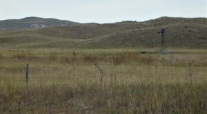
The dunes vary greatly in size and height, so there is enough visual variety to keep you interested. The higher dunes rise to about 400 feet. Be careful hiking here, as much of this land is privately owned and trespassing is prohibited.
Much of the land is devoted to ranching. The grass on these sandhills provides optimum grazing opportunities, so you will see some of the nation’s largest ranches on this route. But make no mistake — this is one of the loneliest roads you will ever travel. Few places south of the Canadian border are this sparsely populated. It is about as far from civilization as you can get in the Lower 48.
If you’re like me, you find that appealing at times. This is a place to come when you are fed up with traffic and congestion. Drink in the isolation.
Hand-Planted: the Nebraska National Forest
Nebraska National Forest is largely the result of planters who wanted to fill the treeless void. Its 22,000-acre section of hand-planted woods is the largest such forest in the world.
When the project started, both the two tracts, miles apart, were treeless sand hill land. But University of Nebraska biology professor Charles E. Bessey proposed planting forests here. At the time of his plan in 1902, lumber harvests were widespread and uncontrolled in other states. Bessey wanted this area to produce wood product to offset a national lumber shortage. Although his original intent never was realized, the result was one of America’s unique national forests. Both serve as oases in a sea of sand and prairie grass.
One is near the panhandle town of Chadron, while the other parallels Route 2 and includes the town of Halsey. Hiking and camping opportunities abound, and you can visit the state’s only fire tower lookout. Tours are available upon request.
Roadside Americana at Carhenge
Years ago, Jim Reinders left his home in Alliance, Neb., a town along Highway 2, for a job in the oil business in the United Kingdom. He visited many of the great British landmarks, including Stonehenge, an ancient World Heritage Site shrouded in mystery. Neolithic and Bronze Age builders somehow managed to create a monument about which archaeologists continue to speculate. Was it a structure for predicting solar events? A druid temple? A place of coronation for Danish kings? Without modern machines, how were the massive stones moved there? How many centuries did it take to build?
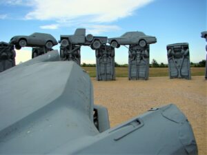
Reinders returned home to Nebraska with a quirky idea — recreate the ancient structure using retired vehicles, each of which would be about the same size as Stonehenge stones. His work unfolded in a matter of days. Curious and cynical residents of Alliance watched in wonder as building materials arrived at a site north of town in 1987.
No boulders are available in this area, but the car wheels made for far easier transport and placement than the ancient builders managed. Reinders used a family reunion to gather workers, who followed his plan and created Carhenge in one week, with a dedication ceremony at the time of the summer solstice. A sign at the site triumphantly proclaims that “Stonehenge West” was created 9,999 years, 51 weeks faster than its British cousin.
In all, it took 39 cars to finish the project. Some are suspended on top of other cars (like the stones at Stonehenge) and others are rooted into the ground at a depth of about five feet. The configuration is an exact replica of Stonehenge.
Carhenge requires a detour of several miles from Route 2. Head north on Highway 87 and look for the Pit Stop Gift Shop and entrance on the right (east) side of the road. There is no admission charge, and the site is open every day during daylight hours (although the gift shop opens only in the summer months).
Historic and Versatile Fort Robinson State Park
Just 3.5 miles west of Highway 2 on U.S. Highway 20 is historic Fort Robinson State Park, a preserved military outpost with a rich past.
Originally established during the Sioux Wars, Chief Crazy Horse died here. The base became home to the 9th Cavalry Regiment, a largely African-American unit that eventually was commanded by Col. Charles Young, the highest-ranking African-American officer in the U.S. Army at that time.
Later, Fort Robinson became prime grounds for breeding and raising horses for the U.S. Cavalry. Toward the end of its active use as a military base, it served as a prisoner of war camp for captured Germans during World War II.
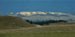
Today, the fort is a preserved installation with a museum, library, officers’ quarters, and blacksmith shop. Adjacent to the fort, you can see herds of buffalo roaming grasslands alongside the Pine Ridge, a system of cliffs that form a dramatic backdrop.
Fort Robinson’s History Center is open from late May through September.
But this is more than a landmark for historians.
Visitors come here in large numbers to host family reunions in the lodges and watch live theatrical productions. That’s right! Post Playhouse (founded 1967) brings in actors and directors from across the country who stage well-known productions such as “Cats” and “Annie.” Check the production schedule for what’s playing during your visit.
Final a Resting Place for a Fearsome Species at Oglala National Grassland
The U.S. Department of Agriculture observes “this unique area consists of native mixed-grass prairie, with forested stream beds and steep, worn, formations created by water and wind erosion on layers of silt stone, and clay.” Within the Oglala National Grassland is Toadstool Geological Park, where huge rock formations resembling toadstools attract visitors, some of whom hunt for fossils in a place where prehistoric bones have been uncovered. Hiking trails of various difficulty levels reveal this unique landscape, and you’ll also find a campground that the U.S. Forest Service operates at certain times of the year.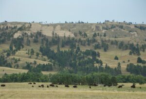
At the Hudson-Meng Bison Kill Research & Visitor Center, it’s possible to watch archaeologists at work documenting a site at which thousands of bison were slaughtered by paleohunters about 10,000 years ago. This discovery could tell us much more about life on the Great Plains in those ancient times.
The north-south Fossil Freeway connects Nebraska sites with a few in South Dakota. Another site for fossil enthusiasts is just 23 miles off of Highway 2: Agate Fossil Beds National Monument south of Harrison at 301 River Road. This fossil bone bed was discovered in the early 1900s and features now-extinct animals that many scientists believe replaced dinosaurs. Among the creatures thought to roam this area were the fearsome Dinohyus, described as a huge, hog-like animal that was larger than a buffalo and “dominated all life forms with its fearsome teeth and angular skull.”
No Dinohyus sightings here lately, but bison herds are plentiful.
After Nebraska Highway 2, Where Next?
The South Dakota border forms the northern limits of Oglala National Grassland. Ardmore, South Dakota (just north of the border) is about 70 miles south of Custer and the heart of the Black Hills, where beautiful Custer State Park and Mount Rushmore await. The trip takes about 80 minutes.
Those are not surprising travel finds, but they’re certainly worth visiting. Further west into Wyoming, Yellowstone and Grand Teton national parks are about a one-day drive.
When you get to these places, you can tell folks that the trip across Nebraska wasn’t so bad after all.
You took Highway 2.