
The moderate-to-strenuous Doe Mountain hiking trail near Sedona frequently left me short of breath. But the view at the end also took my breath away.
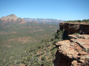
This climb takes you to the top of a large mesa that overlooks Sedona, Arizona on the eastern horizon. But there are equally astounding views from scores of other observation points.
Smart hikers come here to observe sunrises and sunsets, which are legendary in this part of Arizona. The fading light does incredible things to views of the red-rocked mountains, mesas and cliffs.
Because you can drive to it, I chose to view sunset from popular Airport Mesa, on the road to the local airport west of town. It’s a nice view too, but you’ll share it with dozens of visitors. On many days, you’ll have the Doe Mountain view almost to yourself.
But for sunrise or sunset, you’ll need a flashlight and some sure-footed care to navigate the switchbacks and sometimes steep steps leading up or down Doe Mountain.
This is also a place for stargazers!
Far from the light pollution of any major city, Doe Mountain affords a window to the heavens that would be tough to match in most places.
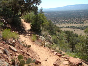
A few specifics on the trail: it’s a 1.5 mile round-trip journey, and the elevation change from the trail head parking lot to the summit is nearly 500 feet. There is loose gravel in spots, making the trail treacherous for those who don’t have sure footing. This is not a hike for someone with severe asthma, bad knees, or mobility issues. You’ll need to be in reasonable shape to reach the top, and you’ll require good light to walk the trail safely. It’s officially categorized as moderate, but experienced hikers say it’s on the strenuous side of moderate. You’ve been warned.
But the rewards for making it to the top are rich and well worth pursuing if you are able.
The combination of height and a relatively central location affords an excellent overview of the entire Red Rock Region. You’ll see many of its iconic rock formations and mountains, including Bear, Maroon, and Wilson mountains, and Chimney Rock. Boynton, Loy, and Secret canyons can also be seen. Don’t get too casual in your observations, as there are no guardrails or fences to protect you from a very long, potentially deadly fall. Stay at least 10 feet from the edges.
Driving to the trailhead takes you into Coconino National Forest, and parking requires a Red Rocks Pass, available for purchase in several locations at a cost of $5 USD for a day or $15 USD for a week. Holders of the America the Beautiful Pass ($80 USD for one year of free admission to about 2,000 recreational areas, including all the U.S. national parks) park without additional cost.
This location is about 120 miles (2.5 hours of driving) from the South Rim entrance to Grand Canyon National Park. Many travelers wisely combine their Grand Canyon excursions with a few days in Sedona.
The trail head is about five miles west northwest of Sedona. Use Dry Creek Road, and then turn left at the Boynton Canyon intersection. The GPS map coordinates are 34°53’36.7″N 111°51’54.5″W. Be aware that the parking lot serves several trail heads, including the Bear Mountain and Aerie trails as well as the path to Doe Mountain.
There is much to see and explore in the Sedona area, yet Trip Advisor ranks the Doe Mountain trail 11th among 141 things to do. I found that ranking long after returning home. In terms of a quality place to visit, the ranking does not surprise. But these lists also usually consider popularity, too. There might be days when the trails are crowded here, but not in my experience.
That’s why I think Doe Mountain near Sedona is a surprising travel find! I was there on a day in mid-June when restaurants in town were crowded and tourist-oriented businesses were buzzing. But I only encountered a few people at Doe Mountain. On many days here, you’ll have the time to appreciate God’s creation in solitude — a time block I highly recommend building into any trip to a scenic area.
Once you catch your breath, you’ll be glad you took the time to visit!
If You Go
Address: Boynton Road, Sedona, AZ 86336. Trail head is about five miles from the center of Sedona | Phone: 928.203.2900 for Red Rock Ranger District | Open: All Year | Hiking Time: Allow about 2 hours round-trip, plus time to admire the views and vegetation | Admission price: Parking permit required (Red Rock Pass is $5 for a day). | Nearest Airport: Flagstaff Airport, 34 miles/57-minute drive | Website: Coconino National Forest